search the site
GNSS disruption at sea level: An interference study in the Baltic Sea

For years, aviation safety organizations and maritime authorities have relied on ADS-B-based reports to assess GNSS interference. Services such as gpsjam.org, spoofing.skai-data-services.com and flightradar24 have provided valuable insights into interference patterns at high altitudes. However, this data tells only part of the story. Ground-based infrastructure — ports, telecommunications networks, and precision navigation systems — operate in a vastly different signal environment. High-altitude detections cannot reliably indicate the presence or impact of interference at sea level.
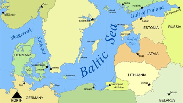
To address this critical knowledge gap, GPSPATRON and Gdynia Maritime University have conducted a six-month study on GNSS interference in the Baltic Sea. Using terrestrial GNSS monitoring technology, the project examined the frequency, duration and characteristics of interference events affecting maritime navigation and other critical applications.
Data collection and analysis
At the core of this study is a terrestrial GNSS monitoring system developed by GPSPATRON, designed to capture and analyze signal disruptions in real-time. Installed at the Faculty of Navigation at Gdynia Maritime University, this system continuously recorded GNSS signal integrity and transmitted the collected data to a cloud-based analytics platform. This platform facilitated the automated detection, classification and visualization of GNSS interference events, providing a comprehensive understanding of interference patterns and their potential impact on maritime navigation. The results paint a stark picture of persistent and evolving interference patterns in the Baltic region. More than 84 hours of GNSS interference were recorded, with October exhibiting the highest activity. Two primary interference types were identified: multi-constellation jamming, prevalent in the summer months, and multi-tone interference, which emerged in October.
Key findings
- Persistent GNSS Interference: A total of 84 hours of GNSS interference was detected, indicating continuous disruptions in the region. Most incidents were caused by jamming rather than spoofing.
- October saw peak interference levels: The month recorded six major jamming events totaling 29 hours, showing an escalation in disruption frequency and severity.
- Maritime sources of interference suspected: Signal pattern analysis confirms that the source was mobile, reinforcing the likelihood of a single ship or multiple vessels operating the same advanced jamming technology.
- High-Precision Jamming Signatures: The interference signals detected exhibit structured modulation patterns and frequency agility, suggesting the use of highly sophisticated jamming techniques. These characteristics indicate high-grade equipment, potentially of military origin, with capabilities far exceeding those of common commercial jammers. The consistency and precision of these disruptions highlight the need for further investigation into the source and intent behind these operations.
- No link to ADS-B reports: Despite extensive ground-level interference, ADS-B-based monitoring systems failed to register corresponding events, highlighting their limitations in assessing terrestrial threats.
- Long-duration disruptions: Some interference events lasted more than seven hours, significantly affecting GNSS-dependent operations in maritime navigation and port activities.
Implications for maritime and critical infrastructure
The findings of this study expose a critical gap in current GNSS monitoring methods. High-altitude interference reports, primarily based on ADS-B data, fail to capture the real impact of jamming and spoofing at ground level. Maritime operations, port logistics, and other critical infrastructure remain vulnerable due to this oversight.
Ports, telecommunications providers, and emergency services rely heavily on GNSS for navigation, timing synchronization, and security. Without precise ground-level monitoring, disruptions can go unnoticed, leading to cascading failures across multiple sectors.
A major concern is the false sense of security created by ADS-B-based detection systems. While these services report daily interference incidents, they do not reflect the full extent of ground-based GNSS disruptions. As a result, infrastructure operators may underestimate the risk, assuming that existing monitoring solutions provide adequate coverage. This misconception is dangerous, as it masks the severity of interference threats that remain undetected in high-altitude datasets.
To mitigate these risks, there is an urgent need for a dedicated GNSS interference monitoring network along the Baltic Sea coast. Such a network would provide real-time, localized data to accurately assess threats, detect interference sources, and enhance infrastructure resilience against GNSS disruptions.
Conclusion
This study confirms that GNSS interference is a persistent issue at sea level, posing a serious threat to critical infrastructure, which predominantly operates at ground level. Prolonged interference events were recorded, some lasting several hours, leading to significant degradation in positioning and timing accuracy. This disruption directly impacts maritime operations, telecommunications, emergency response, and other sectors reliant on GNSS services.
High-altitude interference detection alone is insufficient, as it fails to capture threats affecting ground-level operations. Relying solely on ADS-B-based reports creates a false sense of security, leaving critical systems vulnerable to undetected risks.
To mitigate these risks, there is a clear need for a dedicated ground-based GNSS interference monitoring network. Such a system would provide real-time detection, precise geolocation of interference sources, and timely countermeasures to protect infrastructure.
GPSPATRON and Gdynia Maritime University urge regulatory bodies to take proactive steps toward enhancing GNSS interference detection and mitigation. Without coordinated action, vulnerabilities in national infrastructure will continue to escalate, leading to potentially severe operational and security consequences.
source : gpsworld


